
The rapid growth of the low-altitude economy is creating new opportunities for industries such as logistics, emergency response, urban management, agriculture, and infrastructure inspection. However, as drone operations become more frequent and complex, managing low-altitude airspace safely and efficiently has become a major challenge. Traditional air traffic systems are not designed for the large-scale deployment of unmanned aerial systems, creating the need for intelligent coordination solutions.
UAS Traffic Management (UTM) technologies are emerging as a key foundation for organizing drone activities in low-altitude environments. By combining three-dimensional mapping, real-time monitoring, artificial intelligence, and digital connectivity, modern platforms can provide comprehensive visibility and control. Icecypress Technology develops advanced spatial intelligence solutions, including a low-altitude platform designed to support drone situational awareness and scalable commercial drone operations.

Why Low-Altitude Airspace Requires Intelligent Coordination
Unlike traditional aviation environments, low-altitude airspace involves a large number of diverse drone applications operating close to urban areas and complex ground environments. Delivery drones, inspection UAVs, emergency response aircraft, and industrial drones may all need to share the same airspace while maintaining safety and efficiency.
Without effective coordination, increasing drone activity can create risks such as route conflicts, limited visibility, and inefficient resource management. Operators need accurate information about flight paths, airspace conditions, landing locations, and potential hazards.
A UAS Traffic Management system addresses these challenges by creating a digital framework that connects drones, operators, infrastructure, and regulatory requirements. It enables better planning, monitoring, and coordination of low-altitude operations.
The Role of a Low-Altitude Platform in Future Airspace Management
A low-altitude platform serves as a digital foundation for managing complex drone ecosystems. Instead of relying on independent systems, it integrates multiple types of information into one coordinated environment.
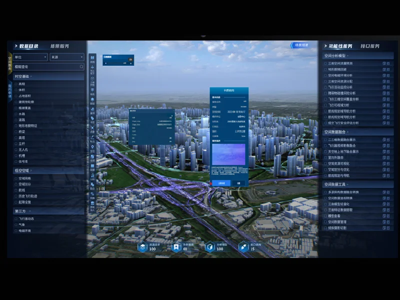
Icecypress Technology’s Low-Altitude 3D Intelligent Operations Platform combines real-scene 3D technology, air-ground integration, and intelligent connectivity. The platform works as a digital “traffic light, controller, and navigation map” for low-altitude operations by providing full-domain drone situational awareness, intelligent planning, and safety control.
Through this integrated approach, organizations can obtain a comprehensive understanding of airspace conditions and support more efficient drone deployment.
Building Drone Situational Awareness Through Digital Integration
Effective drone management depends on accurate and timely information. Drone situational awareness allows operators to understand where drones are operating, what conditions exist around them, and what risks may affect their missions.
A modern low-altitude platform integrates various data sources, including remote sensing imagery, real-scene 3D models, airspace information, IoT sensing data, and business operation data. By combining these resources, the platform creates a unified digital representation of the low-altitude environment.
This “one map” approach provides a single-screen overview of airspace conditions, flight routes, drone status, landing sites, and risk information. It helps different organizations coordinate activities more effectively while reducing duplicated data construction.
How 3D Technology Improves Low-Altitude Operations
Three-dimensional visualization is an important component of intelligent airspace management. Compared with traditional two-dimensional maps, real-scene 3D models provide a more detailed understanding of buildings, terrain, infrastructure, and operational environments.
For drone operators, this additional spatial information optimizes route planning and risk assessment. Before launching missions, teams can evaluate possible obstacles, optimize flight paths, and improve operational safety.
Icecypress Technology applies spatial intelligence technologies to create accurate digital environments that support low-altitude operations. By connecting 3D models with real-time data, the platform helps transform fragmented information into actionable operational intelligence.
Supporting Multiple Industry Scenarios with One Intelligent Platform
The future of low-altitude airspace management requires solutions that can support different application scenarios. A scalable platform should not only manage individual drone flights but also provide long-term support for expanding commercial operations.
Icecypress Technology’s low-altitude platform is designed for multiple use cases, including urban governance, emergency rescue, logistics, modern agriculture, and tourism. Its flexible architecture allows organizations to reuse digital assets and expand capabilities according to changing operational requirements.
For emergency response teams, real-time drone situational awareness can improve decision-making during urgent situations. For logistics operators, intelligent route planning can support more efficient delivery networks. For cities, integrated management capabilities can improve overall low-altitude governance.
Creating Safer and More Efficient Drone Ecosystems
Safety is one of the most important priorities for the development of the low-altitude economy. As drone operations increase, organizations need technologies that can monitor activities, identify risks, and support coordinated responses.
A comprehensive UAS Traffic Management framework provides the foundation for safer drone ecosystems. Through intelligent connectivity and continuous data synchronization, operators can better manage flight activities while improving operational efficiency.
The combination of AI, 3D digital models, and real-time sensing enables a shift from simple drone monitoring toward intelligent airspace management. This creates new possibilities for large-scale commercial drone adoption.
Enabling the Next Stage of Low-Altitude Digital Transformation
The expansion of the low-altitude economy depends on reliable digital infrastructure that can connect drones, airspace, and ground systems. UAS Traffic Management technologies provide the coordination capabilities needed to make future drone operations safer and more efficient.
With its Low-Altitude 3D Intelligent Operations Platform, Icecypress Technology demonstrates how spatial intelligence can support smarter airspace coordination. By integrating real-scene 3D, air-ground connectivity, and intelligent analysis, the platform provides a comprehensive foundation for modern low-altitude applications.
As industries continue exploring drone-based services, intelligent low-altitude management solutions will play an increasingly important role in building connected, scalable, and sustainable aerial ecosystems.
